Template · Land & development site brochure
Land and development site brochure template
A vacant site can’t be toured, so a land brochure has to show on paper what the land allows a buyer to build and how well it connects. Buyers of development, industrial and rural land read the site area, the zoning, the servicing and the access before anything else, and their planner and engineer will check every one of those facts.
This template builds a land brochure, or a full OM when the deal needs one, from your fact sheet or the address: a site overview over satellite imagery, zoning and planning status, servicing, drive times and connectivity, neighbours and the labour or population within reach, with the price per acre or hectare labelled as calculated.
Best for
- Residential, mixed-use and commercial development sites
- Industrial and employment land, serviced or unserviced
- Farm, rural and future-development land with long-term potential
What you need
- The address or coordinates and the site area
- Zoning, official plan or comprehensive plan details you have
- Servicing information, surveys, site plans or studies if available
Upload a fact sheet (PDF, Word, image or a phone photo of a flyer), paste its text, or start from the address. Extracted facts are marked “verify” until you accept them.
What’s inside
- CoverHero aerial or site photo, transaction title, site area and the listing team.
- Site overviewParcel-scale satellite imagery with your site facts when there is no site plan or outlined aerial; your own aerial with the outline you draw when there is.
- Offering and site detailsSite area in acres and hectares, frontage and depth, parcel identifier, asking price or offering process and price per acre (calculated, labelled).
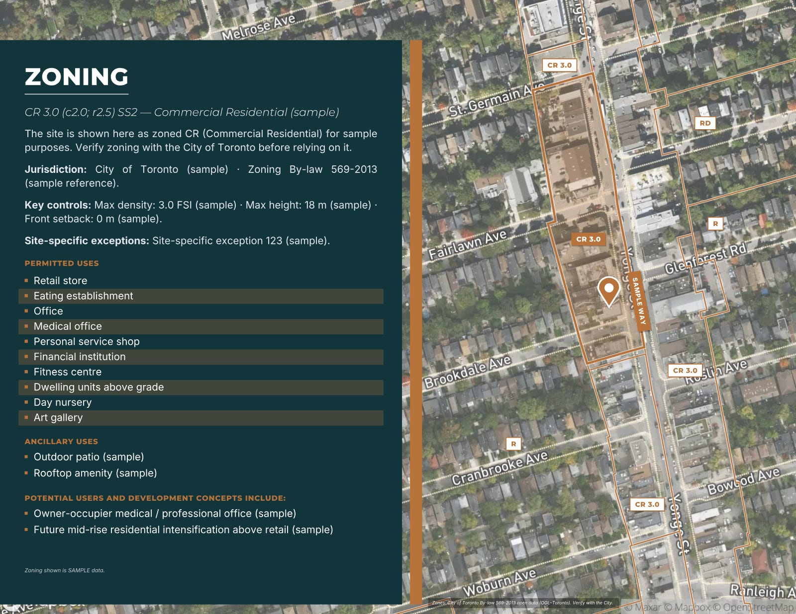
- Zoning and planning statusZone code, the uses that matter to likely buyers, key controls and the status of any planning applications, each with its source.
- Development programConcept, density or unit count you describe, shown only when you enter it.
- ServicingWater, sanitary, storm, power and gas at or near the lot line, with studies listed; utility lines drawn over a top-down aerial when you add them.
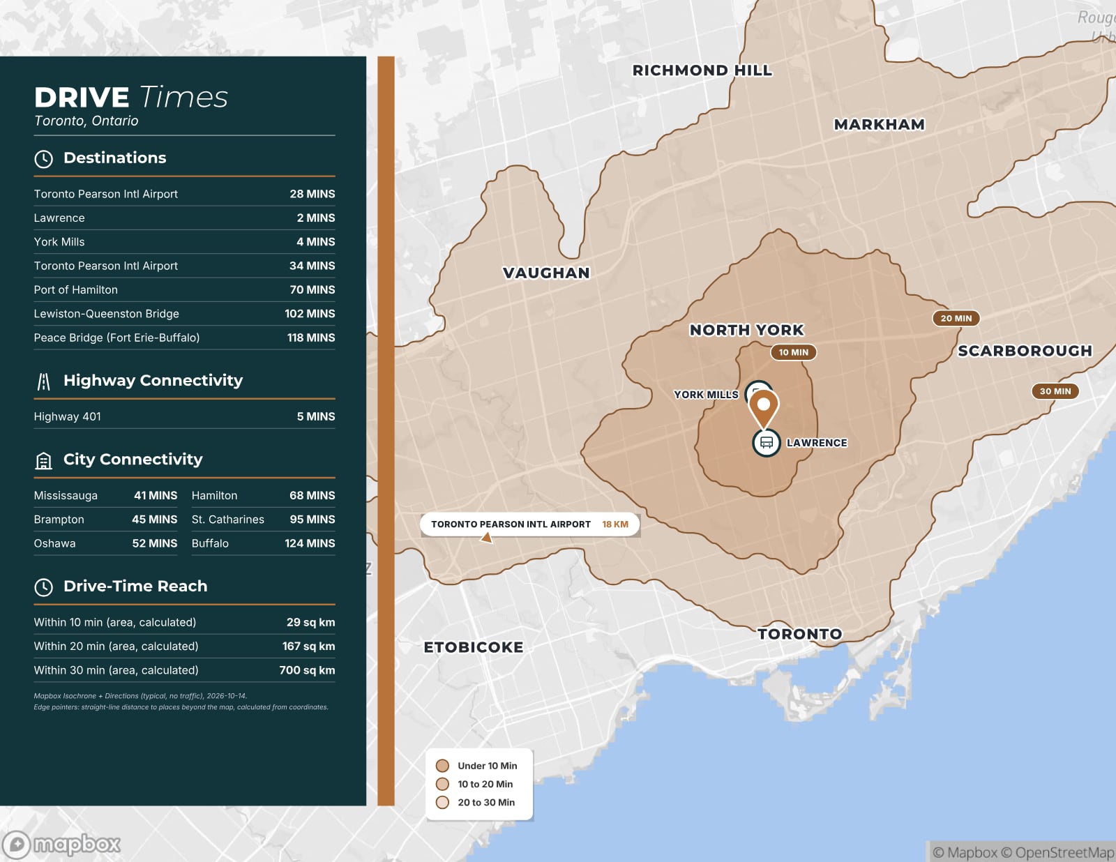
- Access, drive times and connectivity10/20/30-minute drive-time areas, highway interchanges, regional reach rings and a connectivity table by mode.
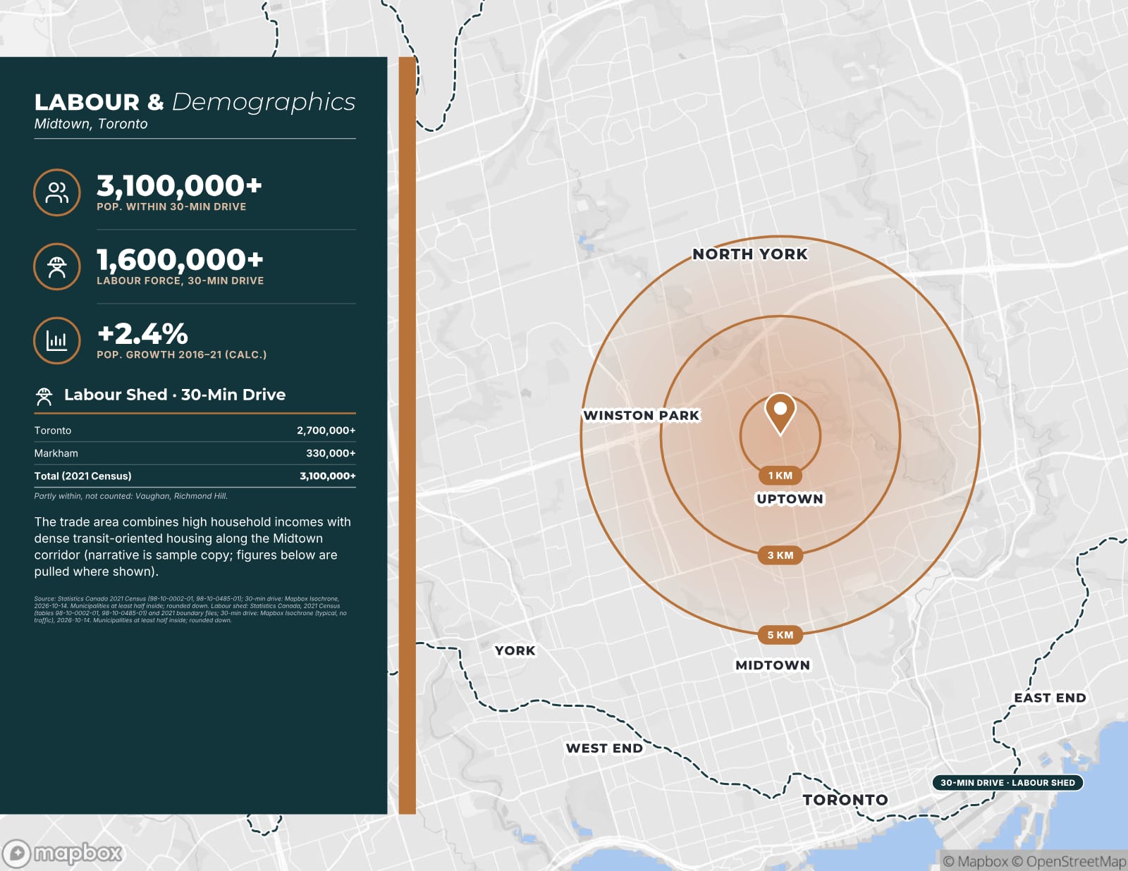
- Neighbours, labour and demographicsNeighbouring occupiers on the map and population or labour force around the site from census tables, sourced and dated.
What buyers check first
- Site area, gross and netAcres and hectares, and the developable area after setbacks, easements, floodplain or natural features.
- Zoning and planning statusWhat is permitted today, the plan designation and any rezoning, site plan or subdivision application.
- ServicingWater, sanitary and storm at the lot line, capacity limits, power supply and who confirmed it when.
- Access and frontageRoad frontage, entrances, distance to highway interchanges and any road widening.
- Environmental and physical constraintsPhase I or II environmental site assessments, flood mapping, slopes, soils and regulated areas.
- Price per acre or per buildable square footThe comparison every land buyer makes, with its basis.
Zoning and planning terms in Canada and the US
In Ontario, land use is set by the official plan and the municipal zoning by-law under the Planning Act; a buyer will ask whether a zoning by-law amendment, minor variance, consent (severance) or plan of subdivision is needed. Other provinces use similar tools under their own acts. In the United States the equivalents are the comprehensive or general plan, the zoning ordinance, rezoning, variances and the subdivision plat, often grouped as entitlements.
Zone codes mean different things in different municipalities, so quote the permitted uses from the by-law or ordinance that applies and date the check. Density is expressed as FSI (floor space index) in much of Canada and FAR (floor area ratio) in the US; state which, and whether it applies to gross or net site area.
Servicing, studies and the questions engineers ask
Servicing often decides what land is worth. For each service say whether it is available at the lot line, the main size where known, any capacity constraint, and the source and date: municipal servicing maps, the vendor or a consultant’s report. If servicing depends on a future extension, say who plans it and when.
- Water: main size, pressure or fire flow if tested.
- Sanitary: main size and allocated or available capacity.
- Storm: outlet and stormwater management requirements.
- Power and gas: nearest infrastructure and available supply, especially for heavy users.
- Studies: functional servicing report, geotechnical, environmental (Phase I and II), traffic, archaeology where required.
Environmental site assessments follow CSA Z768 in Canada and ASTM E1527 in the US. List the reports you have and their dates; buyers will commission their own, but knowing what exists speeds up due diligence.
Costs buyers will add to the price
Land buyers underwrite the site, not just the price. Development charges in Ontario and impact fees in many US jurisdictions can be a large share of total cost, as can parkland dedication, road widenings and off-site servicing. A brochure doesn’t need to calculate them, but naming the ones you know of, with the municipality’s current schedule and its effective date, saves a round of questions.
Price per acre or hectare is the first comparison; for development land the second is price per buildable square foot, the price divided by the floor area the zoning or a concept plan allows. Show the basis of every density figure so buyers can test it.
Imagery that shows the land
Ground photos of a field rarely sell it. The imagery that works for land is an oblique drone photo with the parcel outlined, a top-down aerial at a scale that shows the frontage and neighbours, and a few ground shots of the entrance, the frontage road and any existing structures. Date every image, show north on plans and aerials, and keep the outline faithful to the survey: an outline that includes a neighbour’s yard or excludes a road widening will be found by the buyer’s surveyor.
If a concept plan exists, show it with its author and date and label it as a concept, not an approval. If none exists, a clear statement of the controls (FSI or FAR, height, setbacks) lets a buyer’s architect test the site quickly.
Building it in OfferingStack
Start from the address or coordinates. For land listings without a site plan or outlined aerial, OfferingStack adds a Site Overview page with parcel-scale satellite imagery and your site facts; with your own aerial, the Property Details page shows the outline and labels you draw yourself. The parcel identifier is labelled the way your jurisdiction names it, for example PIN in Ontario, PID in British Columbia and the Maritimes, or APN in the US.
Zoning, development program and servicing pages appear when you enter that information, with services and studies listed as rows, and location pages are built from sourced map and census data. Pages without data are left out, and you approve every page before it is distributed.
Real pages from the product
No multifamily or land sample has been rendered yet, so these pages come from the closest fictitious showcase: “Meridian Commons, 100 Sample Way”, a mixed-use sample with an invented name, address and brands. Every figure marked (sample) is not real.
See a sample for your property type
Fictitious properties, each labelled as a sample.
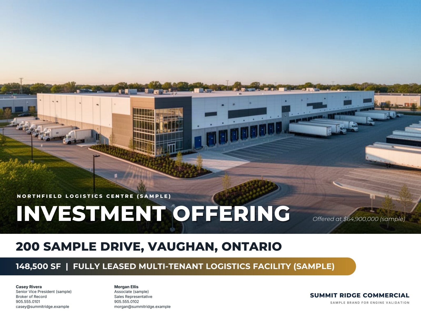
- LandDevelopment, farm and industrial landSample on the wayLand
Questions
Does it work for farm and rural land?
Yes. Land listings without a site plan get a Site Overview page with parcel-scale satellite imagery and your site facts, and the brochure leaves out pages that need data you don’t have, such as servicing or a development program.
Can it show price per acre and per hectare?
Yes. When the asking price and site area are entered, price per acre appears with the pricing figures, labelled as calculated. The free price per square foot calculator also converts to acres and hectares.
Can I outline the parcel on the aerial?
Yes. Draw the boundary and labels yourself in the annotator. Outlines are never invented; without one, the Site Overview page uses the satellite image and your site facts.
What if the zoning or servicing isn’t confirmed?
Enter what you know with its source and date, or leave it blank. Unconfirmed items should be described as such, and pages without data are removed rather than shown empty.
Should I use a brochure or a full OM for land?
Most land listings use a brochure. A full OM makes sense for larger development sites sold through a call for offers, where buyers expect studies, planning history and the offering process in one document.
Start with the fact sheet you already have.
Upload it, answer only what’s missing for the output you choose, and review a watermarked preview before you buy anything.