CRE marketing guide
Presenting zoning, servicing and site plans in a CRE listing
How to present zoning, permitted uses, servicing, surveys and site plans in a brochure or OM so buyers and their consultants can rely on them.
Why these pages get the closest reading
Zoning, servicing and site plans are the pages a buyer hands to their planner, engineer and lawyer. They decide whether the buyer’s intended use is allowed, what it will cost to build or expand, and whether there are surprises on title or on the ground. A brochure can be persuasive everywhere else, but these pages need to be precise.
They are also where listings most often go wrong, usually not through bad intent but because a zone code was copied from an old brochure, a servicing claim was passed along without a source, or a concept plan was presented as if it were approved. This guide covers how to present each one so it holds up in due diligence.
Zoning: quote the by-law, not just the code
In Ontario, zoning is set by each municipality’s zoning by-law under the Planning Act, and the same zone code can mean different things in neighbouring municipalities. An “M2” or “E1” zone tells a buyer very little until they know which by-law it comes from and what it permits.
- State the zone code, the by-law name and number, and any site-specific exception that applies to the property.
- Quote the permitted uses that matter to the likely buyer pool, using the by-law’s own wording.
- Mention uses that are prohibited or restricted if a likely buyer would assume otherwise, such as outside storage or truck parking.
- Give the date you checked the by-law and, ideally, the municipal source.
Some municipalities have a newer comprehensive by-law alongside older ones that still apply to certain properties, or a by-law that is partly under appeal. If you are not certain which provisions apply, say so and suggest the buyer confirm with the municipality. A cautious, sourced statement is worth more than a confident wrong one.
Official plan designation
The official plan sets the long-term intended use of an area, and zoning has to conform to it. For land and redevelopment sites, quote the official plan designation as well as the zoning, especially if the site sits in a designated employment area or if the two point in different directions.
Performance standards and what can be built
Permitted uses say what can happen on the site; performance standards say how much. Buyers of land and of buildings with expansion potential will want the key numbers:
- Maximum lot coverage and floor space index (FSI) or floor area ratio.
- Maximum building height.
- Minimum front, side and rear yard setbacks.
- Parking and loading requirements, which often limit an industrial site more than coverage does.
- Landscaping requirements and any buffer to sensitive uses nearby.
If you show the remaining development potential, such as “approximately X sq. ft. of additional building area”, label it as an estimate, show how it was calculated, and say who calculated it. Buyers will redo this exercise, and an estimate that ignores parking or setbacks will not survive it.
Zoning maps
A zoning map with the parcel outlined and the surrounding zones labelled shows a buyer the planning context in seconds: is the property in the middle of an established industrial area, or on the edge of a residential neighbourhood? Use the municipality’s open data or zoning map as the source, credit it on the page, and date it. Show neighbouring zones only as context, and never imply that a use permitted next door is permitted on the subject property.
Planning status and approvals
If there is any planning activity on the property, describe its status in plain terms: an approved site plan, a pending minor variance, a consent application to sever, a zoning by-law amendment under review. Give the file number if you have it, and say where a buyer can get the documents.
Do not round a pending application up to an approval. “Rezoning application submitted” and “rezoned” are very different statements, and a buyer’s lawyer will check which one is true.
Servicing: what is at the lot line
For land and for industrial users with heavy water, sewer or power needs, servicing can determine whether a deal works. Present it as a short table with one line per service:
- Water: whether municipal water is available at the lot line and the main size, where known.
- Sanitary: availability, main size and any known capacity limits.
- Storm: where storm water outlets, and whether on-site storm water management will be required.
- Hydro: the available supply and the nearest infrastructure; the local utility confirms capacity for a specific load.
- Gas and telecommunications.
Each line should have a source and a date: municipal servicing drawings, the vendor, or a consultant’s report. If a service is not available, say what is planned and according to whom. “Fully serviced” with no detail is one of the first claims a buyer’s engineer will test.
Surveys, site plans and floor plans
A survey shows the legal boundaries, easements and existing structures. In Ontario, the plan of survey or a deposited reference plan is the usual source for boundaries, frontage and site area. Mention any easements or rights-of-way that affect the usable area, and if you show a site sketch instead of a survey, call it a sketch.
A site plan shows how the property is laid out: buildings, parking, truck courts, access points and landscaping. For an existing building, an approved site plan or a clean redrawn version is ideal. For land, a concept plan can help a buyer imagine the site, but label it as conceptual, name who prepared it and never present it as approved.
Floor plans should be to scale or carry a clear “not to scale” note, show the key dimensions, and match the areas quoted elsewhere in the document. Annotate what a buyer will look for: dock and drive-in doors, office areas, washrooms and column grid.
Other constraints worth flagging
Zoning is not the only layer. Part of a site may be regulated by a conservation authority because of a watercourse, wetland or floodplain; a property may be listed or designated under heritage legislation; and road widenings, easements or a hydro corridor can reduce the usable area. If you know of any of these, mention them with their source. Buyers will find them in due diligence, and hearing about them from the listing first keeps the conversation on price rather than trust.
Common mistakes
- A zone code with no by-law reference or permitted uses.
- Zoning copied from an old brochure without checking for amendments.
- Development potential that ignores parking, loading or setbacks.
- “Fully serviced” with no source or detail.
- A pending application described as approved.
- A concept plan with no “conceptual” label.
- Floor plan areas that do not match the areas in the specifications table.
Zoning and site checklist
- Zone code, by-law, exceptions and the date checked.
- Permitted uses quoted from the by-law.
- Official plan designation for land and redevelopment sites.
- Key performance standards; any development estimate labelled with its method.
- Zoning map credited and dated.
- Planning applications described with their real status.
- Each servicing line sourced and dated.
- Survey, site plan and concept plans labelled for what they are.
How OfferingStack helps
OfferingStack builds the property details, zoning and servicing pages from your fact sheet and the property address. Where a municipality publishes zoning as open data, the zoning map outlines the parcel and labels the surrounding zones with a source credit. Values you have not confirmed are marked for you to verify, calculated figures are labelled, and a page with no data is left out rather than shown with blank boxes. You can annotate site plans and floor plans directly in the builder.
What these pages look like
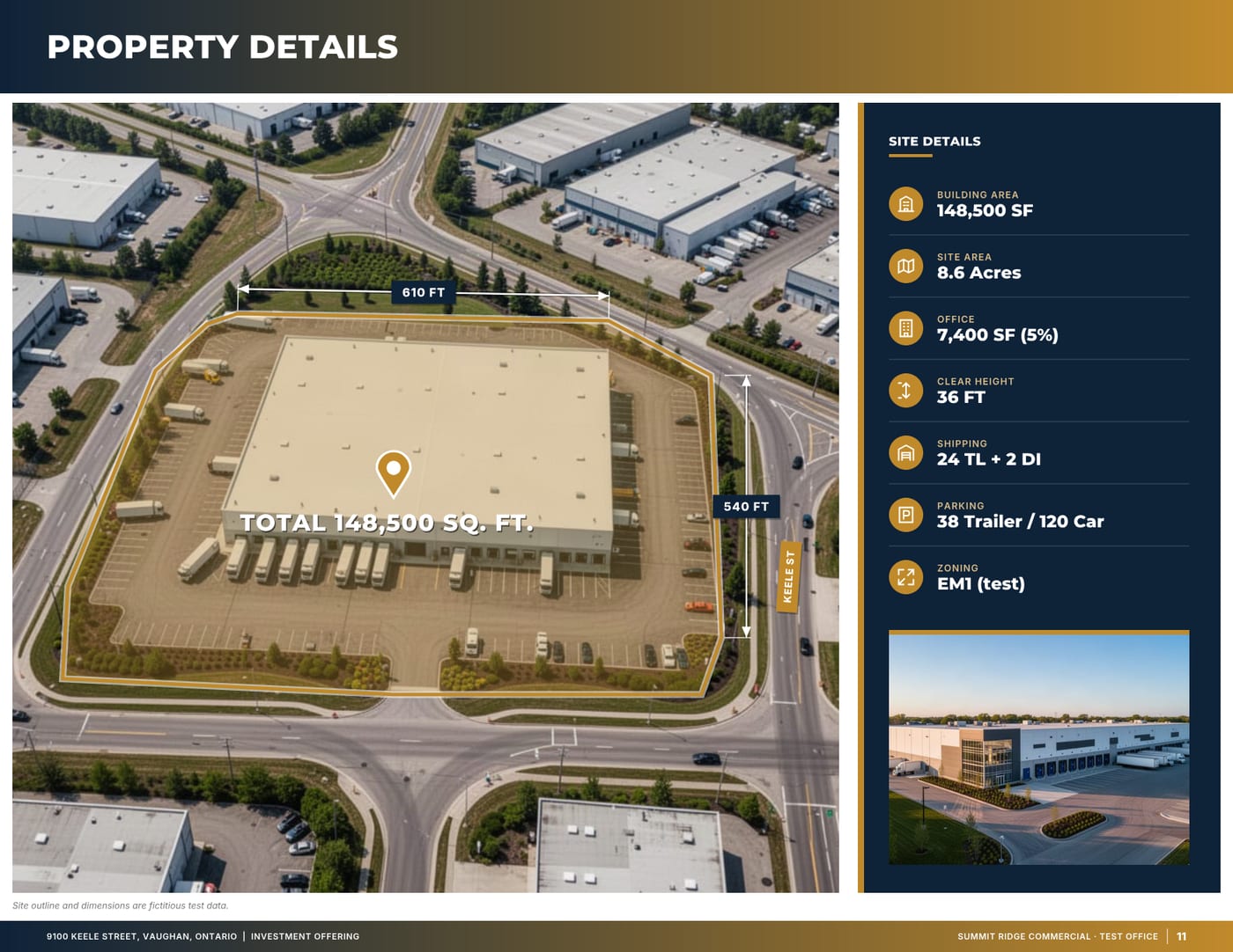
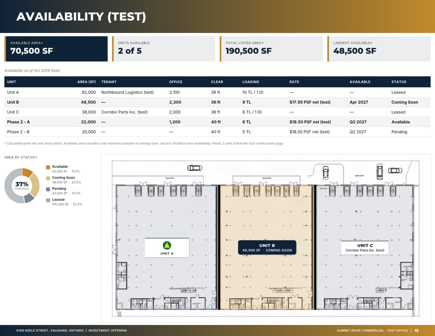
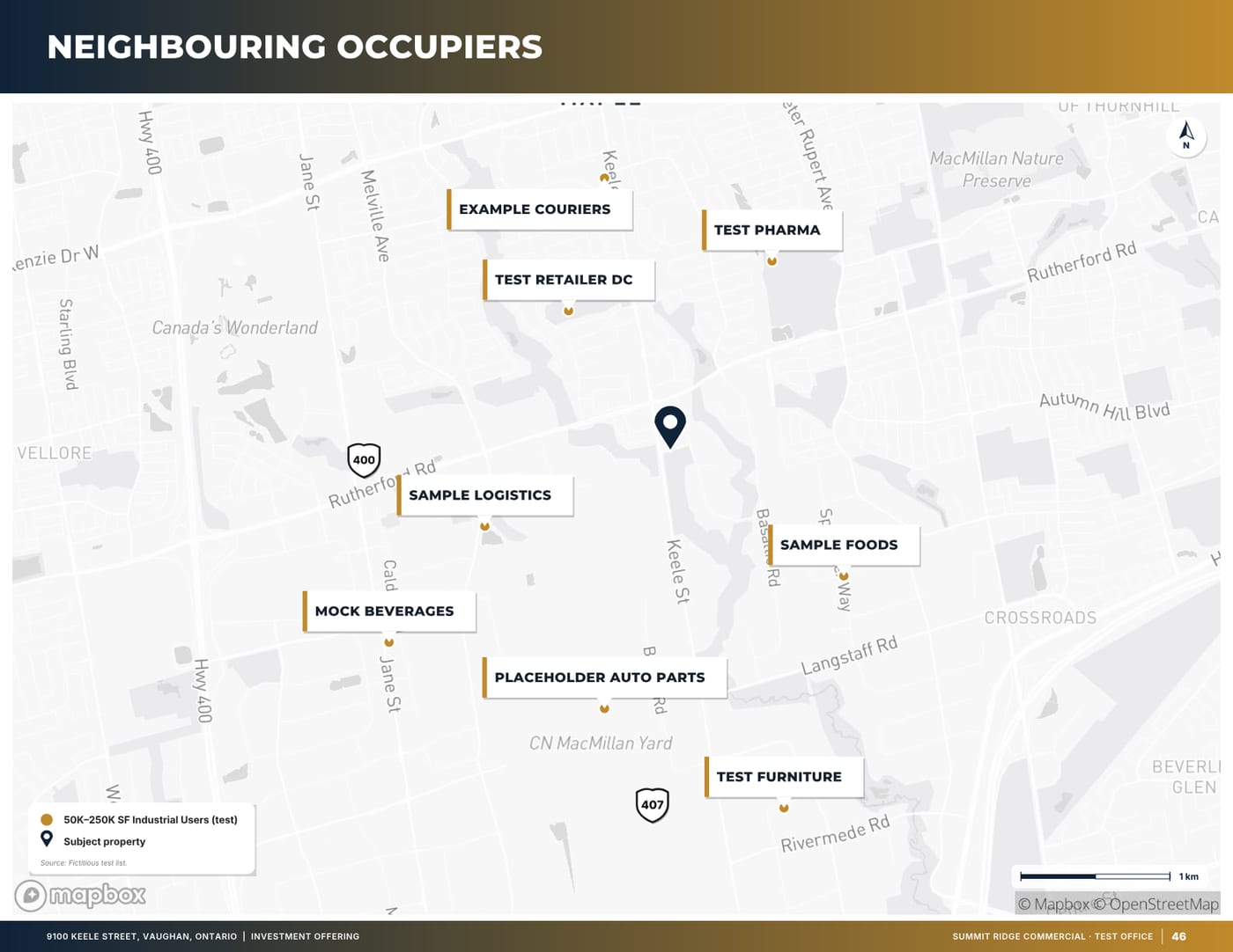
Sample pages are generated by the product from a fictitious test listing (9100 Keele Street, "Summit Ridge Commercial" test brand). Figures marked (test) are not real.
Related
Last updated 2026-10-14. General information for commercial real estate professionals, not legal advice.
Start with the fact sheet you already have.
Upload it, answer only what’s missing for the output you choose, and review a watermarked preview before you buy anything.