CRE marketing guide
Site plans, surveys and floor plans in a commercial listing: what to show and how
Which plans belong in a CRE brochure or OM (survey, site plan, floor, demising and leasing plans), where to get them and how to present them accurately.
Why plans matter more than prose
A buyer or tenant can read a listing description in a minute, but a good plan answers questions that text never settles: where the doors are, how trucks circulate, which part of the building is available, where the parking sits and how the site meets the street. For many commercial properties the plans are the second thing a serious prospect looks at, right after the price or rent.
Plans also carry risk. A plan in a marketing document looks authoritative, so a wrong boundary, an outdated layout or a mislabelled unit can mislead people. The rule of thumb is simple: show the best plan you have, say where it came from, and never draw something you cannot support.
The plans a commercial listing may include
Survey
A plan of survey prepared by a licensed land surveyor (in Ontario, an Ontario Land Surveyor) shows the legal boundaries, dimensions, easements and the location of buildings relative to the lot lines. Brokers rarely reproduce a full survey in a brochure, but it is a key due-diligence document, and the site area and frontage in your marketing should match it. In Ontario you will also meet reference plans (R-plans), which describe parts of lots for conveyancing; say which document a figure came from.
Site plan
A site plan shows the building footprint, parking, driveways, loading, landscaping and access on the lot. It may be an approved site plan from a municipal site plan approval, an architect’s drawing, or a marketing plan prepared from those sources. Label which one it is: an “approved site plan” and a “conceptual site plan” mean very different things to a buyer.
Floor plans
Floor plans show the interior layout: offices, warehouse or retail areas, washrooms, mezzanines and column grids. For leasing, mark the available space clearly and give each unit’s area in the same measure used everywhere else in the listing.
Demising and leasing plans
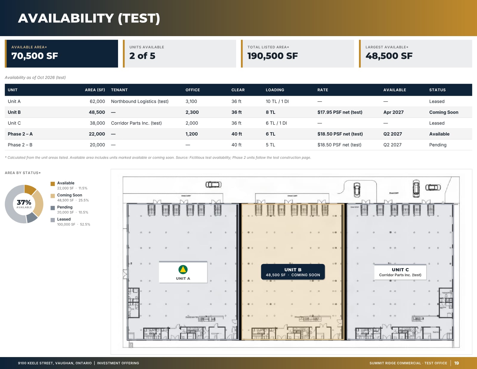
When a space can be divided, a demising plan shows the options (for example two or three units with their areas and door allocation). A leasing plan for a multi-tenant property shows which units are available, which are leased and, where the landlord allows it, who the tenants are.
Where the plans come from
Ask the client early. Owners often have drawings from the original construction, a past site plan approval, a recent survey from a refinancing, or a property manager’s leasing plans. The municipality may hold approved plans for the property; access rules vary, so ask the owner to request them if needed. For land, the survey and any draft plans or concept plans prepared for the owner are the usual sources.
If you only have an aerial photo, you can still show the property clearly by marking it on the photo, as long as the outline is approximate and labelled as such. Do not present an outline traced on an aerial as a legal boundary.
Presenting plans in a brochure or OM
- Clean the drawing: remove title-block clutter, old revision clouds and stamps that are not relevant, without changing the content.
- Orient it consistently (north up, or say if it is not) and add a north arrow where the original has one.
- Use your brand colours for highlights: one colour for available space, another for leased or excluded areas.
- Number the units or callouts and put the areas in a small table beside the plan rather than in tiny text on the drawing.
- Add a source line: “Site plan: based on drawings provided by the owner, not to scale”.
- Keep the plan large: a site plan squeezed into a corner of a page helps no one.
In a brochure, one site plan and one floor or leasing plan are usually enough. In a full OM, add the floor plans for each level, demising options and the survey summary (area, frontage, easements) where you have them.
Areas on plans: say how they were measured
The single most common plan problem in commercial marketing is an area that does not match. The building area on the site plan, the unit areas on the leasing plan, the rentable areas in the rent roll and the figure in the MLS listing may each have been measured differently, at different times, by different people. Readers notice, and every mismatch raises a question about everything else in the document.
Before you publish, decide which figure is authoritative for each purpose and label it: gross building area from the drawings, rentable area under the measurement standard named in the leases (BOMA standards are common for office and industrial space), site area from the survey. If a unit has been re-measured, update every plan and table at the same time. When a figure is an estimate, say so; “approx.” is honest, a false precision is not.
Plans for land and development listings
For land, the plans do even more of the selling, because there is no building to photograph. A survey extract or a clean lot diagram with dimensions, frontage and any easements lets a developer test a concept quickly. If the owner has commissioned a concept plan or a feasibility study, it can be a strong marketing piece, but it must be labelled as conceptual and should not imply approvals that do not exist.
Pair the lot plan with the zoning summary and the servicing status so a buyer can see the whole picture: what can be built, what is connected at the lot line and what would have to be extended. Our guide to zoning, servicing and site plans covers how to present those pages.
- Lot diagram or survey extract with dimensions and frontage.
- Easements, rights-of-way and any known encumbrances that affect the developable area.
- Concept plan, clearly labelled, only with the owner’s approval.
- Aerial with an approximate outline drawn by you, marked as approximate.
Accuracy and disclaimers
Plans in marketing are illustrations, not legal descriptions. Keep the usual statements: not to scale unless the plan says so, areas approximate and subject to verification, buyers and tenants to rely on their own review of the survey and drawings. Those statements do not cure an error, though, so check that the areas on the plan match the areas in the rest of the document and in the MLS listing.
If a plan shows proposed work (a future expansion, a conceptual layout for land), label it clearly as proposed or conceptual and do not mix it with the existing-condition plan.
How OfferingStack handles plans
OfferingStack has dedicated pages for a site plan, floor plans with zones and numbered callouts, demising options and an availability (leasing) plan with unit outlines. Each page appears only when you provide the plan or the units, so a listing without plans simply has no plan pages instead of an empty frame. On aerial photos, outlines and labels appear only where you draw them yourself in the annotator; the engine never draws a property boundary for you. You review every page before you download it.
Checklist before the plans go out
- Every plan has a source line and a date or revision where known.
- Areas on the plans match the spec block, the rent roll and the MLS listing.
- Available, leased and excluded areas are colour-coded consistently.
- Proposed or conceptual layouts are labelled as such.
- Outlines on aerials are marked approximate.
- The client has approved the plans for release (some owners prefer to share floor plans only after a confidentiality agreement).
What these pages look like
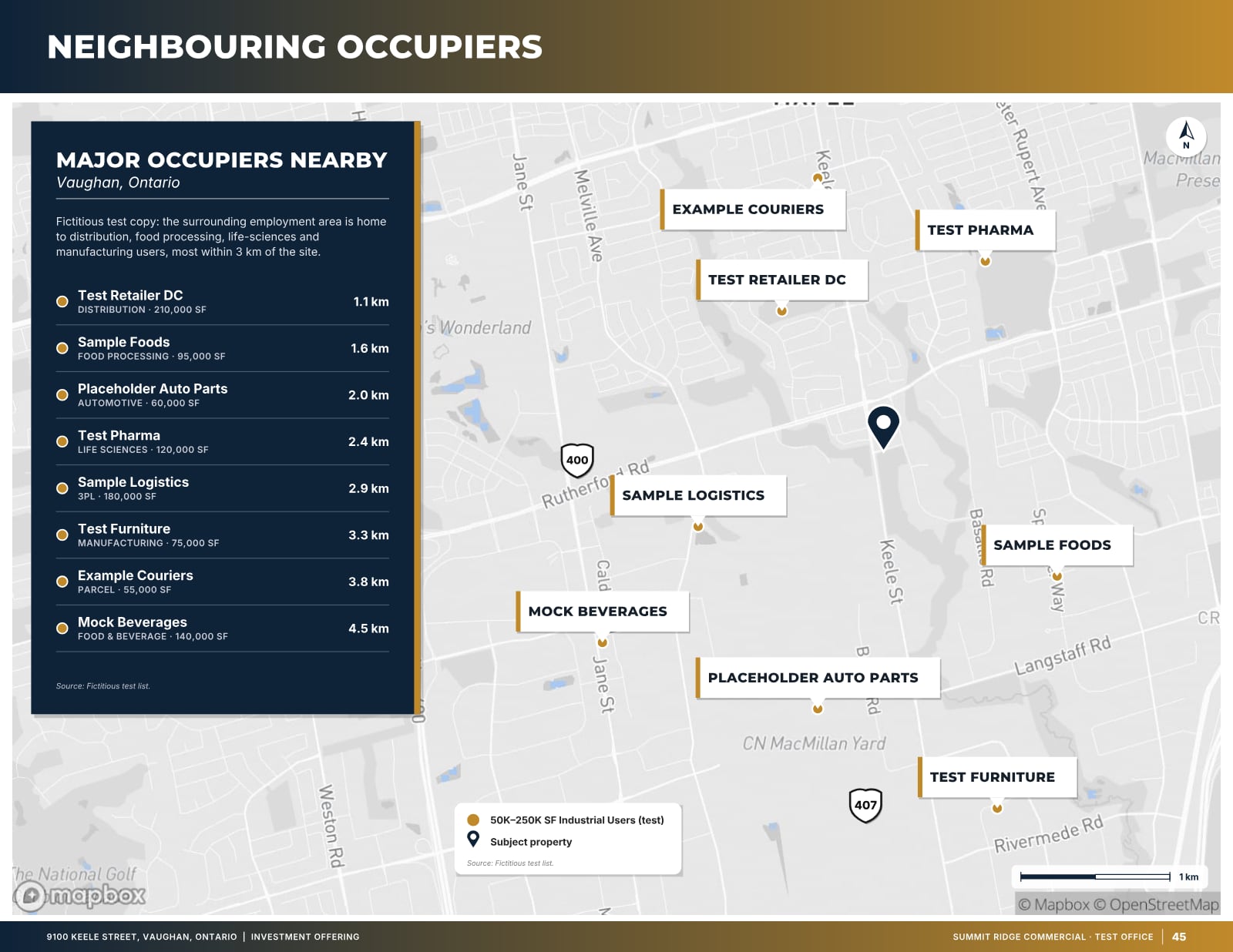
Sample pages are generated by the product from a fictitious test listing (9100 Keele Street, "Summit Ridge Commercial" test brand). Figures marked (test) are not real.

Related
Last updated 2026-10-14. General information for commercial real estate professionals, not legal advice.
Start with the fact sheet you already have.
Upload it, answer only what’s missing for the output you choose, and review a watermarked preview before you buy anything.